Explore CommunityWalk
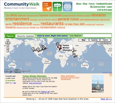
CommunityWalk, the web 2.0 mapping community, has launched the new Explore feature. The Explore page lets you zoom into the map, select a category, or use a live search to find different public maps on CommunityWalk. You can even enter a search for a specific area of the map, or right click to zoom out. As you click through locations, photos are pulled up below the map dynamically.
Please visit Jared’s blog post – Explore CommunityWalk! to see the new release highlights.

Explore CommunityWalk:
http://www.communitywalk.com/explore
Jared Cosulich, CEO of CommunityWalk and the agile team at Pivotal have done the heavy work making it a reality and adding a host of new features. Great job guys. Ideacodes helped with the design and UI.
Update: a number of other people have mentioned CommunityWalk today, including:
CommunityWalk Redesign Makes Google Maps More Attractive and Fun at Social Software @ Weblogsinc
CommunityWak, Google Mpas the Next Generation at RSS Blogger.
NetSquared – remixing the Web for social change by Richard MacManus at Read/Write Web.

3 Comments
Join the discussion and tell us your opinion.
That looks fantastic. I’m so glad you guys are working with community walk. It’s one of my favorite Gmaps services for sure. We’ve written it up as a case study and used its service to map other case studies at Net Squared (a project to bring tech vendors and nonprofits together in the web 2.0 space http://netsquared.org ) The more professional it looks and acts, the more likely some nonprofit orgs will feel comfotable using it, too!
So big congrats on another step in its development.
Thanks, Marshall! Keep up the great work at Net Squared. I just noticed Richard MacManus wrote about Net Squared and CommunityWalk as well.
Phew, when I read the name of the website just now, I was thinking maybe you had done exactly what I had last week (see bimblog.net which I have submitted for Emily to look at a few days ago).
I like what you have done, a sort of ‘metamap’ system….
So my big question – how do I give your site a geocode data feed from my site so you can put it into a map on yours??? That’s where your site could get very interesting …
I have my own map on my site which is live linked into a database, so I can’t use or need to use yours; it sort of links Flickr to the ‘bimbles’ on my site via a Google Map. It would be cool to have that map shadowed on your site!